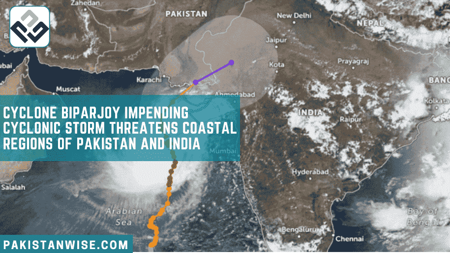
Cyclone Biparjoy, an extremely severe cyclonic storm, is currently located approximately 600km south of Karachi, according to the Pakistan Meteorological Department (PMD). The environmental conditions favor the system’s sustained intensity, and it has shifted northward, approaching Latitude 19.5°N and Longitude 67.7°E.
The PMD’s latest notification states that Biparjoy is expected to track further northward until June 14, after which it will recurve northeastward and make landfall between Keti Bandar in Southeast Sindh and the Indian Gujarat coast on June 15. Widespread wind-dust/thunderstorm rain with heavy falls, accompanied by strong winds, is anticipated in various districts of Pakistan. Additionally, the Indian state of Gujarat is also preparing for the cyclone’s potential impact.
The PMD’s cyclone warning center in Karachi is vigilantly monitoring Biparjoy’s progress and issuing updates accordingly. The center has advised fishermen to avoid venturing into the open sea until June 17 due to the expected rough sea conditions and high tides along the coast.
To ensure the safety of residents, Sindh Chief Minister Syed Murad Ali Shah has directed the concerned authorities to secure billboards and establish close coordination with various military and security agencies. Although the cyclone’s trajectory has shifted away from Karachi, the city is still expected to experience heavy rainfall.
All relevant authorities will remain on emergency duty until the cyclone threat subsides. The CM has urged citizens to refrain from unnecessary outdoor activities during the inclement weather.
The India Meteorological Department has warned that Cyclone Biparjoy may strike Gujarat, a western state of India. The Gulf of Kutch houses two major ports, Mundra and Kandla, while Saurashtra is home to the Jamnagar refinery, the world’s largest oil refinery complex owned by Reliance Industries.
To address the imminent danger, India has deployed seven teams of the National Disaster Response Force and 12 teams of the State Disaster Response Force in the potentially affected districts. The Chief Minister of Gujarat, Bhupendra Patel, confirmed the deployment via Twitter.
While heavy rainfall and gusty winds are expected to affect nearly a dozen coastal districts, the damage may be limited in some sparsely populated areas. An official from the weather office, who requested anonymity, provided this information to Reuters.
Cyclone Biparjoy poses a significant threat to coastal regions in both Pakistan and India. The Pakistan Meteorological Department and India Meteorological Department are closely monitoring the cyclone’s progress and issuing timely warnings and updates.
Both countries have taken precautionary measures to protect lives and property, deploying disaster response forces in vulnerable areas. As the cyclone approaches, it is crucial for residents to adhere to safety guidelines and avoid unnecessary outdoor activities. By remaining vigilant and prepared, the affected regions can mitigate the potential risks associated with this powerful cyclonic storm.
13 June 2023 Cyclone Biparjoy Update
Pakistan – Cyclone, an extremely severe cyclonic storm, is currently located approximately 490 to 500 kilometers away from the city of Karachi over the Arabian Sea. Over the past 12 hours, it has been moving towards the north-northwest direction. According to the latest reports, the cyclone is expected to continue in the same trajectory for the next 12 to 24 hours. However, by June 14, it is anticipated to take a sharp turn towards the north-northeast, potentially making landfall near the Gujarat border area and crossing the Keti Banda region in southeastern Pakistan.
The meteorological department has issued warnings for heavy to extremely heavy rainfall in the affected regions, particularly in the Keti Banda area and the southeastern parts of Pakistan near the Indian Gujarat border. Karachi, too, is likely to experience heavy rainfall events starting from the night of June 13, 2023, until around June 16 or 17. Residents are advised to take necessary precautions to ensure their safety.
As the cyclone approaches, wind speeds are expected to increase, especially in the vicinity of the cyclone’s center. The regions of Keti Banda, Ibrahim, and the nearby southeastern areas of Sindh are projected to witness winds ranging from 100 to 120 kilometers per hour, posing potential damage risks. In Karachi, wind speeds are also anticipated to rise, reaching around 70 to 80 kilometers per hour. Some areas within the city may even experience wind speeds of 80 to 90 kilometers per hour.
Additionally, wave height is expected to escalate as the cyclone moves closer to the coastal regions. The Keti Banda and Ibrahim areas may face wave heights of approximately 8 to 12 feet. Along Karachi’s coastline, rough seas and wave heights ranging from three to five feet are expected.
Cyclones are formed due to imbalances created over the sea surface, influenced by factors such as sea temperatures and climatic patterns. They gain strength as they traverse over open waters. Cyclones are categorized based on their intensity, with Category 1 and Category 2 storms considered strong systems, while Category 3 and Category 4 storms are classified as very strong or extremely strong systems. The highest category, Category 5, designates a super cyclonic storm.
Local authorities are closely monitoring the cyclone’s progress and advising residents to stay updated with the latest weather bulletins and follow any evacuation instructions issued. It is crucial to take all necessary precautions and ensure the safety of oneself and others during this cyclone event.
Remember to stay indoors, secure loose objects, and avoid venturing out into risky areas during heavy rainfall and strong winds.

